This is a geologic map of Britain. It is a screen shot of the British Geologic Survey’s “Geology of Britain” viewer.

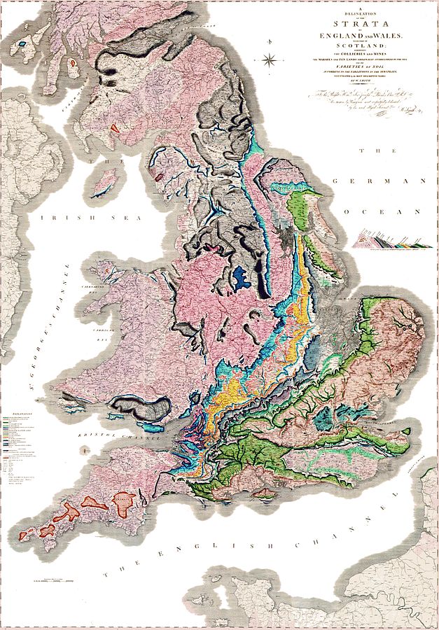
I chose to show bedrock and surface geology because that’s what William Smith showed when he produced the first geologic map of Britain two hundred years ago in 1815.
Unlike many of the English men who made great scientific contributions, William Smith was not nobility – or even well off. He was the son of a farmer. As a young man, he became an apprentice to a surveyor. He eventually went to work for the Somersetshire Coal Canal Company.
While working in the mines, Smith noticed that individual layers of rock on the sides of the pit were always arranged in the same recognizable relative order. He also noticed that some layers were identifiable by the fossils they contained, and that these fossils were also always in a predictable order. He was inspired to see if the relationship between the layers of rock or strata, their positions and the fossils they contain was consistent throughout Britain.
As William Smith studied the rocks of England, he drew cross-sections showing relationships and maps showing location. Eventually his work evolved into the first national geologic map. It measured 6 feet by 8.5 feet and showed the rocks of Britain at the a scale of 5 miles per inch.
Smith’s map isn’t so different from the BGS map created using GPS units and satellite data.
Two hundred years ago, one man created a map by walking through Britain. Since then, geologic maps have been created for every part of the Earth. Thanks to William Smith, mapping is an intergal part of the training of every geologist.
As a geology student, I learned to map in the field by carefully measuring and plotting geologic contacts, folds and faults on a topographic base map. It wasn’t always easy to distinguish between the greyish-brown of one unit and the brownish-grey of another or determine my location based on map contours. Yet, I eventually learned to make a map that could be interpreted to tell the geologic history of a small area. William Smith didn’t have a topographic base map. How did he do it?
Smith’s map is more than the distribution of rocks. It is a first edition volume of Britain’s geologic history. Since 1815, that volume has been edited and revised hundreds of times, but William Smith is remembered and honored as the original author.
You learn more about William Smith and his maps and play with an interactive William Smith mapping app here.
Edited some typos (12/7/15)
